


| By: Paul S. Cilwa | Viewed: 5/13/2024 Occurred: 7/14/2017 |
Page Views: 1043 | |
| Topics: #Places #USA #Arizona #SunsetCraterNationalMonument | |||
| All the photos from my first summer visit to Sunset Crater National Monument. | |||
With Keith's and my wedding date approaching at a terrifying rate, we decided to select a venue in or near Flagstaff, a compromise location between Keith's family in Shiprock, New Mexico, and mine in Chandler and Mesa, Arizona. To facilitate finding this place, we decided to camp for a couple of nights in the vicinity; and the place I suggested was a campground on National Forest land just outside the gate to Sunset Crater National Monument. And, lo and behold, that turned out to be the perfect location.
Our route to Sunset Crater from Phoenix took us past the rest stop at which we always stop, Sunset Point. You'd think, by this time, after having taken dozens of photos from this overlook, that I'd be done with that. But no, every trip it looks different, as the infinitely varying sky can change the look from cheery to foreboding.

I had hoped that, on a Thursday, Bonito Campground wouldn't be overly crowded; and I was right. The sites are large, flat and fairly level. There's no power, but there are several clean restrooms.
Currently the cost of camping here is $24 a night. However, if one possesses a Senior Park Pass, as I do, that price is cut in half.
When we arrived, the camp host explained that they didn't take credit cards; and we didn't have quite enough cash to cover the $24 for two nights. So we had to drive back about 5 miles to a gas station with an ATM. But the host let us call dibs on a site, and, even though it was his largest site and usually used by motor homes, he allowed us to stay since we had picked it first.

I intentionlly faced the door of the tent towards a wash or gully just behind our campsite. The dark material is cinders from the last eruption of Sunset Crater Volcano, almost a thousand years ago.

View From The Tent®

Keith and I drove into town for breakfast (at Denny's), then returned to check out the park before lunch.
Our first stop was the Aa Flow Trail. (That's not a typo; it's pronounced AH-ah.) This jumble of cooled lava came from a flow almost a thousand years ago; and plants are only just now starting to get a foothold.

Lava is not soil. It takes centuries of action by lichen to change the rock to soil, and then the action of many trees and other plants to make it a rich loam that can support more than pine trees and scrub.
Volcanoes in Hawaii recover quickly because of all the rainfall. Here, rain is far more scarce so revegetation takes much longer.

There are innumerable holes and tubs in the lava. Some are mere indentations, while others may have once been active vents, spewing steam and gases into the atmosphere.

Because hot lava contains gases under pressure which explode outward when the lava is released into the air, the chunks cool into these fantastic, logic-defying shapes.

It's at the edges of this 2-square-mile lava field that life begins its colonization.


Our next stop was the Lava Flow Trail. This one-mile, paved, self-guided tour allows the visitor to stroll along the beds of cooled lava that spewed out here 1,000 years ago.

This is the New Amphitheatre, which I considered for a wedding spot. However, it wasn't very private, as the trail goes right past it. This is normally used for ranger presentations.

Among the flowering plants that have taken hold here is Apache Plume.

The lava here, while not as wild as on the Aa Flow Trail, is still about 100 feet thick in most places, having poured right over older volcanoes in this field.


Meanwhile, lava that shot high into the atmosphere collected into droplets that quickly cooled, forming a hail of cinders that covered older, extinct volcanoes in this field of volcanoes that begins with the San Francisco Peaks.

Sunset Crater is now extinct, as is common with cinder cone volcanoes—they tend to be one-hit wonders. But another volcano could well erupt in this field. Should that ever happen, it's expected it would be further to the East, as the continental plate slowly slides over this magma hot spot.


After hiking the Lava Flow Trail, Keith and I returned to the car and headed East toward the Wupatki National Monument, just 15 miles away. This whole area, even outside Sunset Crater National Monument, is part of the 800 square miles that the eruption covered with cinders and ash.

This is Sunset Crater from the lesser-photographed East side.


Here we can see a stretch of the Painted Desert in the distance.


As we grew more distant from the center of the eruption, more outcroppings of the underlying geology began to appear.

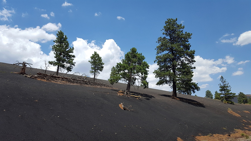
The contract of the green Pnderosa pines and the dark gray cinders is really amazing to behold.


This meadow, just outside the monument, with the San Francisco Peaks as a backdrop, is where Keith and I agreed to hold our wedding.

With the Peaks in one direction and Sunset Crater's portrait view in the other, this places us near one of the Navajos' sacred mountains.


Bonito Campgraound has an amphitheater of its own. This is also a spot I proposed as a wedding location, either for the ceremony or the reception (since it comes with seating).

By the time we returned to our tent, the heavens opened with a monsoon rain. No worries; we were ready to relax in our tent awhile, anyway. The torrent didn't last, and Keith took a turn cooking dinner outside when it stopped.
